Cospas Sarsat System is a satellite system designed to provide alert and location information to aid search and rescue (SAR) operations worldwide. The term “Cospas” originates from the Russian phrase meaning “space system for the search of vessels in distress,” while “Sarsat” stands for “search and rescue satellite-aided tracking.”
Features of Cospas Sarsat System.
Key Features Cospas Sarsat Satellites System are:
- The system utilizes both satellites and ground stations to detect and locate signals transmitted by Emergency Locator Transmitters (ELTs) operating at frequencies of 121.5 MHz, 243 MHz, and/or 406 MHz.
- It offers global support to organizations responsible for air, sea, or ground SAR operations, helping to locate and rescue distressed individuals or vessels.
- The basic configuration of the Cospas Sarsat Satellites System includes:
- ELTs capable of transmitting VHF and/or UHF signals during emergencies.
- Instruments onboard geostationary and low-orbiting satellites that detect signals emitted by ELTs.
- Local user terminals (LUTs) responsible for receiving and processing signals transmitted via satellite downlinks to generate distress alerts.
- Mission control centers (MCCs) tasked with receiving alerts from LUTs and forwarding them to Rescue Coordination Centers (RCCs) for action.
- Search and rescue (SAR) units that respond to distress alerts and carry out rescue operations as needed.
Overall, the Cospas Sarsat Satellites System plays a critical role in enhancing global SAR capabilities by providing timely and accurate distress alerting and location information, thereby increasing the chances of successful rescue missions and saving lives in emergency situations.
Cospas Sarsat Satellites System Explanation
There are two Cospas Sarsat Satellites System, one operating at 121.5 MHz (VHF) and the other at 406 MHz (UHF). The 121.5 MHz system utilizes low earth orbit (LEO) polar-orbiting satellites in conjunction with associated ground receiving stations. The basic system setup is illustrated in Figure below.

In this system:
- Emergency Locator Transmitter (ELT) beacons transmit signals that are received and relayed by Cospas Sarsat LEO-SAR satellites.
- These satellites then pass the signals to Cospas Sarsat Local User Terminals (LUTs), which process the signals to determine the location of the ELT.
- The calculated position of the ELT transmitter is then relayed via a Mission Control Center (MCC) to the appropriate Rescue Coordination Center (RCC) or Search and Rescue Point of Contact (SPOC).
This setup enables rapid and accurate detection of distress signals from ELTs, facilitating swift response and rescue operations to aid individuals or vessels in distress.
Cospas Sarsat System Working Principle.
The Cospas Sarsat Satellites System employs Doppler location techniques, utilizing the relative motion between the satellite and the distress beacon to accurately locate the Emergency Locator Transmitter (ELT). The carrier frequency transmitted by the ELT remains reasonably stable during the period of mutual visibility between the beacon and the satellite.
Doppler performance is particularly effective due to the low-altitude near-polar orbit utilized by the Cospas Sarsat Satellites System. However, it’s important to recognize that the location accuracy of the 121.5 MHz system is not as precise as that achievable with the 406 MHz system.
Additionally, the low-altitude orbit allows the system to operate with very low uplink power levels, enhancing its efficiency and reducing the need for high-powered transmissions. Despite these advancements, the 406 MHz system generally offers superior accuracy compared to the 121.5 MHz system due to its more stable frequency and other technical advantages.
A near-polar orbit has the potential to offer full global coverage, but there are constraints with the 121.5 MHz system. This frequency can only be detected if the uplink signals from the Emergency Locator Transmitter (ELT) are received by a Local User Terminal (LUT). Consequently, the effective coverage of the 121.5 MHz system is limited to a geographic area of approximately a 3,000 km radius around each LUT. Within this region, both the ELT and the LUT are within the satellite’s view.

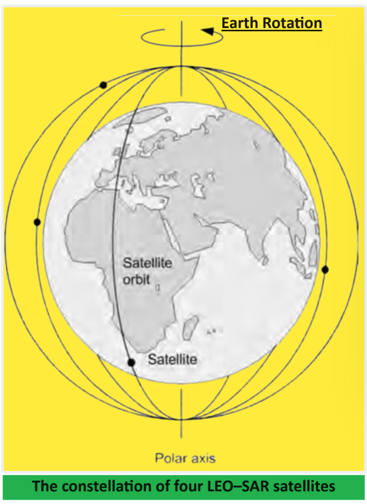
Figure below illustrates the polar orbit of a single satellite. The path, or orbital plane, of the satellite remains fixed, while the Earth rotates underneath. As a result, it takes at most one half rotation of the Earth (i.e., 12 hours) for any location to pass under the orbital plane.
By introducing additional satellites with orbital planes at right angles to each other, the waiting time for coverage is significantly reduced. With a second satellite, only one quarter of a rotation or a maximum of six hours is required.
The complete Cospas Sarsat Satellites System consists of four satellites, as depicted in Figure below. This configuration typically ensures a waiting time of less than one hour at mid-latitudes. However, users of the 121.5 MHz system must wait for a satellite pass that allows for a minimum of four minutes of simultaneous visibility of an Emergency Locator Transmitter (ELT) and a Local User Terminal (LUT). This requirement can prolong the waiting time to several hours, especially if the transmitting beacon is at the edge of the LUT coverage area.
Doppler location techniques provide two positions for each beacon: the true position and its mirror image relative to the satellite ground track. For 121.5 MHz beacons, a second pass is usually necessary to resolve this ambiguity.
Sarsat satellites also feature 243 MHz repeaters, enabling the detection and location of distress beacons operating at this frequency. The operation of the 243 MHz system mirrors that of the 121.5 MHz system, albeit with fewer available satellites.
In contrast, the Cospas Sarsat 406 MHz System is more sophisticated and involves both orbiting and geostationary satellites. The use of 406 MHz beacons with digitally encoded data allows for unique beacon identification. To ensure positive aircraft identification, it’s crucial that 406 MHz ELTs are registered in a recognized ELT database accessible to search and rescue authorities. This database contains information about the ELT, its owner, and the aircraft on which it’s mounted, which can be invaluable in SAR operations.
The unique coding of a UHF ELT is embedded during the final stage of manufacture, using aircraft data supplied by the owner or operator. Subsequently, the ELT data is registered with relevant national authorities and entered into a database accessible for interrogation by SAR agencies worldwide. This comprehensive registration process enhances the efficiency and effectiveness of search and rescue operations.