Air navigation refers to the process of planning, monitoring, and controlling the movement of aircraft from one location to another through the airspace. It encompasses a range of activities and techniques used by pilots and air traffic controllers to ensure the safe and efficient passage of aircraft. This includes route planning, determining position, maintaining altitude and speed, navigating around obstacles, communicating with air traffic control, and adhering to established flight rules and procedures. Air navigation relies on various aids and technologies, such as radio navigation systems, satellite-based navigation systems (like GPS), radar, visual navigation cues, and flight instruments, to guide aircraft along their intended routes and ensure they reach their destinations safely.
What is Air Navigation?
Air navigation involves guiding an aircraft from one point to another while ensuring safety and efficiency. Pilots use various tools and systems to maintain their course, avoid getting lost, prevent collisions, and minimize the impact of weather conditions. This includes relying on navigation aids, instruments, and communication with air traffic control to navigate through airspace and reach their destination securely.
Air Navigation History
In the early 20th century, aviation navigation relied on basic techniques like terrain observation, maps, and compasses.
1. Dead reckoning
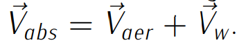
Dead reckoning was later introduced, which involved estimating the aircraft’s future position based on its current speed, direction, and time. Pilots used anemometers to measure airspeed and clocks for timing, navigating between points marked on maps. However, dead reckoning was prone to errors, mainly due to instrument inaccuracies, pilot mistakes, and the impact of wind. Despite improvements in instruments and pilot training, wind effects remain a significant factor in determining aircraft trajectories, shaping concepts like the triangle of velocities and track and course angles.
2. Track Angle (TR):
The track angle is the angle between the north direction (usually magnetic or geographic) and the absolute velocity of the aircraft. It represents the actual path the aircraft is following through the air. The absolute velocity of the aircraft is the sum of its aerodynamic velocity and the wind speed. This concept is visualized using the triangle of velocities.
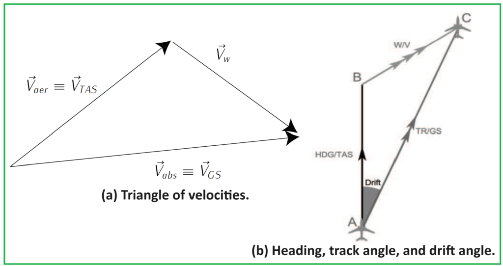
3. Course Angle (HDG).
The course angle, also known as the heading, is the angle between the north direction (typically magnetic or geographic) and the aerodynamic velocity vector of the aircraft. It usually corresponds to the direction in which the aircraft is pointed, but it may differ from the track angle due to the influence of crosswinds. In symmetric flight conditions, the course angle aligns with the longitudinal axis of the aircraft.
4. Desired Track (DTR) Angle.
The desired track angle is the angle between the north direction (usually magnetic or geographic) and the straight line connecting two consecutive waypoints in a flight plan. It represents the intended path that the aircraft should follow ideally between waypoints.
5. Cross-Track Error (XTE).
The cross-track error is the perpendicular distance between the aircraft’s position and the desired track line. It indicates how far off-course the aircraft is and is calculated as the shortest distance between the aircraft’s position and the desired track line. Thus X T E = d(DT R, T R), where d can be defined as the norm 2 (the euclidean distance).
6. Bearing.
The bearing is the angle between the north direction (typically magnetic or geographic) and the straight line connecting the aircraft to a reference point. The reference point is often a navigational aid on the ground or a waypoint calculated based on the positions of multiple ground-based navigational aids. The bearing depends on the selected reference point and is used to determine the direction of the aircraft relative to that point.
Astronomic Navigation
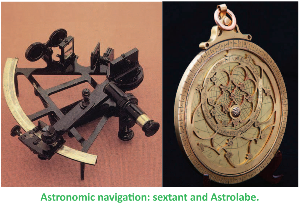
Astronomic navigation emerged as a solution to the limitations of dead reckoning navigation, particularly in adverse weather conditions or over featureless landscapes like oceans. Dead reckoning relied on visible reference points, which could be challenging to identify in poor weather or darkness.
To overcome this challenge, early aviators turned to astronomic devices such as the astrolabe and sextant, which had long been used in maritime navigation. These devices allowed pilots, often aided by navigators, to periodically determine their position using celestial bodies like stars.
By combining astronomic navigation with dead reckoning, pilots could minimize errors and navigate more accurately. This approach played a important role in landmark flights, such as those undertaken by Alcock and Brown in 1919 and Lindbergh in 1927, enabling them to reach their destinations without becoming lost.
Navigation Aids
Navigation aids have played a important role in the evolution of aviation, facilitating safer and more efficient flights. Initially, autonomous navigation techniques relied on celestial observations and dead reckoning, but these methods were labor-intensive and prone to errors. To address these challenges, ground-based navigation aids were developed.
In 1918, aerial beacons were introduced to assist with night flights over networked areas. Subsequently, radio communications and radio-goniometry were utilized to determine aircraft orientation relative to ground-based transmitters. The Low Frequency Radio-Range (LFR), introduced in 1932, became a primary navigation system for instrument flying until the emergence of VHF omnidirectional range (VOR) in the late 1940s. LFR relied on directional radio signals transmitted from ground towers, with pilots interpreting Morse codes to navigate airways.
Over time, navigation aids evolved significantly. The introduction of VOR and Distance Measuring Equipment (DME) in the late 1940s and early 1950s, the concept of Area Navigation (RNAV) in the late 1960s and early 1970s, and the automated Instrument Landing System (ILS) approach in the late 1960s all contributed to navigation advancements. Furthermore, the development of satellite navigation systems further enhanced navigation capabilities.
Today, instrumental navigation techniques, aided by sophisticated navigation aids, are the primary means of navigating aircraft, ensuring safer and more efficient flights.
Air Navigation in the Presence of other Aircraft
In the early days of aviation, navigation primarily focused on the challenges of flying safely and avoiding getting lost. However, with the growth of air traffic and the establishment of airports, the concept of navigation evolved to include the management of aircraft circulation to prevent collisions. Circulation in air navigation refers to the movement of aircraft around specific structures in airspace or along predefined routes.
To address the increasing complexity of air traffic, rules and procedures were developed to ensure aircraft could see and be seen by others, minimizing the risk of mid-air collisions. Additionally, the need arose for individuals with the expertise to coordinate aircraft movements and assign takeoff and landing sequences. These roles laid the groundwork for modern air traffic control systems.
In 1935, the United States established its first air route control center, marking a significant milestone in the development of air traffic management systems. This center played a pivotal role in overseeing and directing the flow of aircraft along designated air routes, contributing to safer and more efficient air travel.
The air navigation as a system
The evolution of air navigation necessitated the development of legal, operational, and technical frameworks to regulate the system effectively. Within this framework, several key elements were identified:
- Technical and Operational Support: This includes systems providing vital information to pilots before departure, such as meteorological data, operational constraints, and limitations associated with navigation aids. Additionally, tactical support during flight helps pilots adapt to changing conditions and avoid potential conflicts with other aircraft or adverse weather.
- Radio-electric Infrastructures: Essential for providing navigation aids to aircraft, these infrastructures form the backbone of the air navigation system, enabling pilots to navigate safely and efficiently.
These components form the foundational pillars of the air navigation system, known as the Communication, Navigation, Surveillance/Air Traffic Management (CNS-ATM) concept. In subsequent sections, we will delve deeper into the technical and operational aspects of this framework.
On the other hand, the legal framework governing air navigation encompasses various aspects, including:
- Aeronautical Personnel Formation and Licensing: Ensuring that individuals involved in aviation possess the necessary qualifications and licenses to perform their duties safely and effectively.
- Communication Systems and Procedures: Establishing rules and protocols for communication between aircraft and ground control.
- Regulations on Aircraft Systems and Performance: Setting standards for aircraft equipment and performance to ensure safe operation.
- Air Traffic Control Regulations: Governing the management and coordination of air traffic to prevent collisions and maintain orderly airspace.
- Aircraft Certification, Registration, and Identification: Establishing requirements for the certification, registration, and identification of aircraft engaged in international flights.
- Aeronautical Meteorology, Maps, and Navigation Charts: Providing regulations and standards for the dissemination of meteorological information and the production of navigation charts and maps used by pilots.
While this overview provides a glimpse into the legal framework of air navigation, a more comprehensive examination of air law will be conducted in subsequent courses.
The International regulation (juridic) framework
The international regulation framework for air navigation evolved over the course of the 20th century to accommodate the growing complexity of aviation. Initially, the primary concern was simply enabling flights, but this expanded to include the ability to fly anywhere, even in adverse conditions, while ensuring safety and avoiding collisions.
To address the need for uniformity in regulations and equipment standards, the International Commission for Air Navigation (ICAN) was established in 1919. However, it was the signing of the Chicago Convention in 1944 that laid the foundation for modern international civil aviation regulations. The convention aimed to promote the safe and orderly development of international aviation, covering aspects such as safety, security, efficiency, and environmental protection. Out of this convention, the International Civil Aviation Organization (ICAO) was formed, which continues to develop and implement international aviation regulations.
In Spain, the Airports and Air Navigation division of AENA (Aeropuertos Españoles y Navegación Aérea) is responsible for ensuring the safety and efficiency of civil air traffic. AENA serves as the Air Navigation Service Provider (ANSP) in Spain. Additionally, AESA (Agencia Estatal de Seguridad Aérea) oversees civil aviation standards and safety regulations, operating under the Ministry of Public Works and Transport.
In Europe, the European Civil Aviation Conference (ECAC) serves as the regulatory body, while EUROCONTROL acts as the ANSP. In the United States, the Federal Aviation Administration (FAA) fulfills both regulatory and ANSP roles. These organizations work together to ensure the safe and efficient operation of air navigation systems.
Discover more from PAKTECHPOINT
Subscribe to get the latest posts sent to your email.