The Global Navigation Satellite System (GNSS System) is a constellation of satellites that provide autonomous geo-spatial positioning with global coverage. It includes systems such as GPS (Global Positioning System) developed by the United States, GLONASS developed by Russia, Galileo developed by the European Union, and BeiDou developed by China. GNSS systems enable users to determine their precise location, velocity, and time information anywhere on Earth’s surface or in its vicinity, using signals transmitted by satellites in orbit. These systems have diverse applications, including navigation for air, sea, and land vehicles, surveying, mapping, timing synchronization, and location-based services.
What is GNSS System?
GNSS System (Global Navigation Satellite Systems) operate by transmitting electromagnetic signals from satellites to receivers on Earth, providing information such as time and pseudo-distance. Pseudo-distance is derived from the time it takes for the signal to travel from the satellite to the receiver, but it is affected by timing errors between the satellite’s clock and the receiver’s clock.
These systems, such as GPS (Global Positioning System) and GLONASS (Global Navigation Satellite System), aim to provide precise positioning, global coverage, and continuous navigation capabilities. However, there are challenges associated with their practical use in certain applications, particularly in aviation.
One significant issue has been the strategic nature of these systems concerning national security. Historically, systems like GLONASS were initially limited to military use, with civilian access restricted. Even when opened to civilian use, limitations may exist, as in the case of GLONASS in 2007.
GPS, being maintained by the United States government, has been relatively more open for civilian use, with free accessibility to anyone with a compatible receiver. However, concerns regarding precision, continuity of coverage, and signal integrity persist, particularly in critical applications like aviation. The military nature of these systems means that there may be limitations or disruptions in service during times of conflict or intentional interference.
Despite these challenges, GNSS systems have become integral to modern navigation across various sectors, though mitigating strategies and alternative navigation methods may still be necessary in sensitive or high-stakes applications.
In response to the limitations and concerns surrounding the use of GNSS system for critical applications like aviation, the concept of GNSS augmentation systems was developed. GNSS augmentation involves integrating external information into the calculation process of GNSS signals to improve attributes such as accuracy, reliability, and availability.
The first generation of GNSS system, known as GNSS-1, aimed to address these issues by combining existing satellite navigation systems like GPS and GLONASS with augmentation systems. These augmentation systems provide additional information that enhances the performance of GNSS.
Augmentation systems can provide various types of information, including:
- Sources of satellite error: This includes data about factors such as clock drift, ephemeris errors (errors in satellite position), and ionospheric delay (delay caused by the Earth’s ionosphere affecting signal propagation).
- Additional aircraft information: This may include data specific to the aircraft’s position, velocity, attitude, and other relevant parameters. Integrating this information into the calculation process can further enhance the accuracy and reliability of navigation solutions.
By integrating such external information, GNSS augmentation systems can mitigate the limitations of standalone GNSS systems, making them more suitable for critical applications like aviation. However, even with augmentation, backup systems are typically maintained to ensure navigation safety and reliability, especially in scenarios where GNSS signals may be unavailable or degraded.
Types of Augmentation System
There are three main types of augmentation systems designed to enhance the performance of GNSS:
1. Satellite-Based Augmentation System (SBAS):
- SBAS supports wide-area or regional augmentation by utilizing additional satellite-broadcast messages.
- Multiple ground stations strategically located across the coverage area take measurements of GNSS satellite signals.
- These measurements are used to generate information messages, which are then sent back to the satellite constellation.
- The satellite constellation broadcasts these messages to end users, such as aircraft.
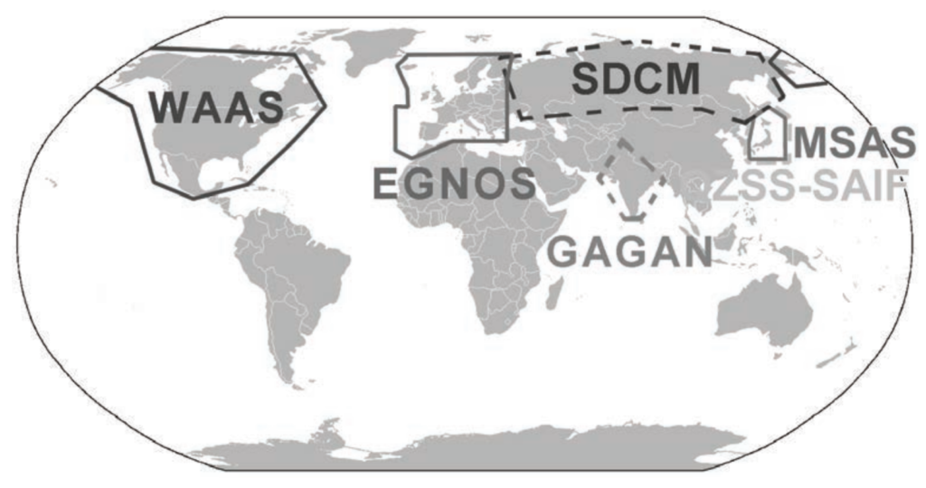
- Regional SBAS implementations include systems like WAAS (Wide Area Augmentation System) in the US, EGNOS (European Geostationary Navigation Overlay Service) in the EU, SDCM (System for Differential Correction and Monitoring) in Russia, MSAS (Multi-functional Satellite Augmentation System) in Japan, and GAGAN (GPS Aided Geo Augmented Navigation) in India.
2. Ground-Based Augmentation System (GBAS):
- GBAS provides augmentation using terrestrial radio messages instead of satellite broadcasts.
- Similar to SBAS, terrestrial stations measure GNSS signals and generate information messages.
- However, in GBAS, these messages are directly transmitted to end users, such as aircraft, without being relayed through satellites.
- Examples of GBAS implementations include LAAS (Local Area Augmentation System) in the US.
4. Airborne Based Augmentation System (ABAS):
- In ABAS, ground stations analyze information received from aircraft rather than directly augmenting GNSS signals.
- Information analyzed by ground stations is then transmitted back to aircraft to improve navigation performance.
- ABAS systems provide additional integrity and accuracy checks, enhancing the reliability of GNSS-based navigation.
- ABAS implementations may vary depending on specific aircraft and avionics systems.
These augmentation systems play critical roles in improving the accuracy, reliability, and integrity of GNSS-based navigation, making them essential components of modern aviation systems.
GNSS-2 and Other Navigation System
GNSS-2 represents the next generation of satellite navigation systems, aiming to provide full civilian satellite navigation capabilities with the accuracy and integrity required for air navigation. These systems are designed to offer reliable navigation solutions for various applications, including aviation.
One prominent example of a fully civilian satellite navigation system is the European Galileo system, which has been developed to provide independent global navigation and positioning services. Galileo aims to offer improved accuracy, integrity, and availability compared to existing systems like GPS and GLONASS.
Additionally, efforts were underway to develop a civil version of GPS, further expanding the availability of civilian satellite navigation services and enhancing the resilience and redundancy of global navigation systems.
Apart from satellite-based systems, hyperbolic navigation systems have been historically used for aircraft navigation, utilizing radiotelemetry to determine the aircraft’s position by intersecting hyperboloids of revolution. Examples of hyperbolic systems include LORAN-C, Omega, and DECCA.
LORAN-C (Long Range Navigation) was a widely used hyperbolic navigation system that provided long-range navigation capabilities, particularly in maritime and aeronautical applications. However, advancements in satellite-based navigation systems, such as GPS and Galileo, have largely replaced LORAN-C and other hyperbolic systems due to their superior accuracy, coverage, and reliability.
Overall, while hyperbolic navigation systems like LORAN-C have historically played a significant role in navigation, the evolution of satellite-based GNSS technology has led to their diminished usage in favor of more advanced and versatile satellite navigation solutions.