In the vast expanse of the skies, where precision and accuracy are paramount, aircraft rely on sophisticated measurement instruments for navigation. From determining altitude to calculating airspeed, these instruments play a crucial role in ensuring the safety and efficiency of flight operations. In this article, we delve into the world of measurement instruments for aircraft navigation, exploring their functions, principles, and importance in aviation.
Instruments for Aircraft Navigation
Instruments for Aircraft Navigation
When an aircraft is flying, it needs various kinds of information to know where it is and how it’s moving. This information comes from different instruments on the plane.
- Barometric Altimeter: This device measures the air pressure around the aircraft to figure out its altitude, or how high it is above the ground.
- Pitot Tube: This tool measures the speed of the air flowing past the aircraft, which helps determine how fast the plane is moving through the air.
- Accelerometers: These instruments track how the plane is speeding up or slowing down by sensing changes in its acceleration.
- Gyroscopes: Gyroscopes monitor the plane’s changes in direction and how fast it’s turning.
- Magnetic Compass: By sensing the Earth’s magnetic field, the aircraft can figure out its direction, or the course it’s flying in.
These instruments work together to provide important data for navigation during flight.
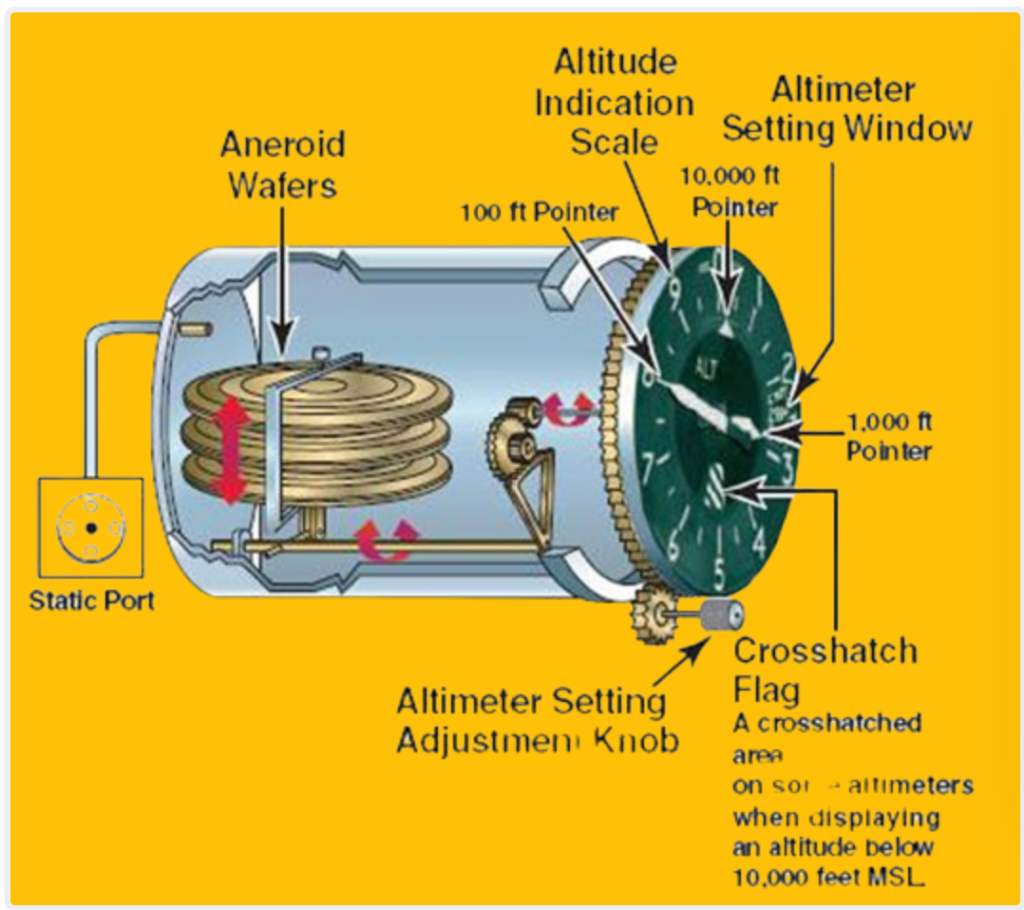
1. Barometric Altimeter
A barometric altimeter is a tool used to figure out how high an aircraft is by measuring the air pressure. In aviation, there’s a standard called International Standard Atmosphere (ISA) that helps relate pressure to altitude. An aneroid barometer, which measures atmospheric pressure, is mounted on the outside of the aircraft to collect this data.
The aneroid altimeter can be set up in three different ways: QNE, QNH, and QFE. Each setting represents a different reference point for altitude measurement: sea level, a specific airport, or a standardized pressure level of 101225 pascals.
Here’s a breakdown:
- QNE setting: Altitude is measured based on the standard pressure level of 101225 pascals.
- QNH setting: Altitude is measured relative to sea level.
- QFE setting: Altitude is measured relative to a specific airport’s elevation.
A barometric altimeter typically has a dial or display that shows the altitude based on these pressure measurements. It’s an essential tool for pilots to know how high they are flying.
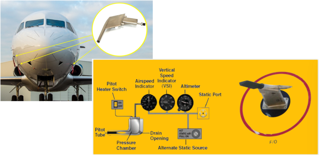
2. Pitot Tube
A pitot tube is a tool that helps measure how fast air is flowing past an aircraft, which is crucial for determining the airspeed. It’s a simple yet effective device consisting of a tube that points directly into the airflow. As the air enters the tube, it comes to a stop, creating what’s called stagnation pressure.
This stagnation pressure, measured by a pressure sensor, gives us important information about the airspeed. However, it’s not enough to directly calculate the airspeed. We need to use Bernoulli’s equation, which relates fluid velocity to pressure, to figure out how fast the air is actually moving.
By applying Bernoulli’s equation, we can determine the velocity of the incoming airflow, and thus the airspeed of the aircraft. The pitot tube is typically mounted on the exterior of the aircraft, and its design ensures accurate measurement of airspeed.
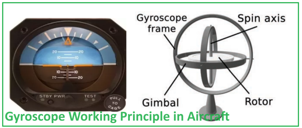
3. Gyroscopes
A gyroscope is a device, either mechanical or electronic, that relies on the principle of conservation of kinetic momentum. Essentially, it’s like a spinning cylinder with a lot of inertia rotating at a high speed. This rotation keeps the cylinder pointing in the same direction, regardless of external forces acting on it. Imagine a spinning top that always stays upright even if you tilt the surface it’s on.
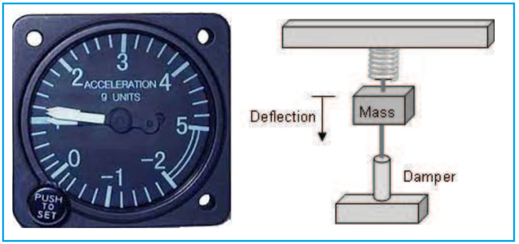
On the other hand, an accelerometer measures accelerations by detecting changes in position. It typically consists of a mass-damper system connected to a spring. When the accelerometer experiences acceleration, the mass inside it gets displaced. By measuring this displacement, we can determine the acceleration, following the principles of basic physics and Newton’s Second Law.
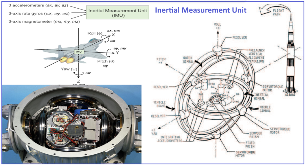
4. Accelerometers:
Accelerometers usually work in a single direction, so we need three of them to cover all three dimensions of space. When combined with gyroscopes, which measure angular acceleration, they form what’s called an Inertial Measurement Unit (IMU). This unit is used for inertial navigation, a method of determining an object’s position and attitude without external references.
5. IMU (Inertial Measurement Unit)
By integrating the measurements from the accelerometers and gyroscopes and starting with initial values of position and attitude, an IMU can calculate the current position, velocity, attitude, and angular velocity of an aircraft. This information is vital for navigation, especially in situations where external references like GPS might not be available.
Aircraft utilize various technologies to gather information crucial for navigation. One method involves emitting electromagnetic waves outward, which bounce off the ground and return to the aircraft. This is how radio-altimeters determine altitude above the ground. Additionally, aircraft can use meteorological radar to detect clouds along their intended path.
Moreover, aircraft receive electromagnetic waves from dedicated aeronautical radio infrastructures. These include systems like VOR (VHF Omnidirectional Range) and NDB (Non-Directional Beacon) for navigation during flight and ILS (Instrument Landing System) and MLS (Microwave Landing System) for precise approaches and landings.
In recent years, satellite navigation systems such as GPS (Global Positioning System), GLONASS, and the upcoming GALILEO have become essential for accurate and reliable navigation. These systems provide precise positioning data to aircraft, improving overall navigation efficiency.
Aircraft are equipped with onboard navigation instruments that receive, process, and display this information to the pilot. These instruments play a vital role in helping pilots navigate safely and effectively, especially during challenging conditions or in remote areas where visual references may be limited.